
Prof. Paul R. Baumann |

|
COPYRIGHT © 2022 Paul R. Baumann |
|
Remote sensing started with aerial photography and has progressed today into digital satellite imagery. The first aerial photograph was taken in 1858, 102 years before the term "remote sensing," came into existence in 1960. Long before satellites and computers started dominating the field of remote sensing, innovative individuals were developing unusual platforms and cameras in order to take aerial pictures of the Earth's surface. Obtaining these pictures was not an easy task and at times people risked their lives in the development of aerial photography. |
 |
|
First known photograph, taken in 1827. |
|
In 1826, Joseph Nicèphore Nièpce (pronounced Nee-ps) reportedly took the first photograph. Nièpce set up a device that he named "camera obscura," which captured and projected scenes illuminated by sunlight. His first picture shows a view from his studio window in eastern France. The photograph was cast on a treated pewter plate that, after many hours, retained a crude copy of the buildings and rooftops outside the window. With the exposure lasting so long, the sun had time to move from east to west, creating an image in which the sun appears to be shining at the same time on the opposite sides of two buildings. |
 |
|
In 1829, Nièpce entered a partnership arrangement with Louis Jacques Mande Daguerre, which lasted only a few years with Nièpce dying in 1833. Daguerre continued their work and in 1839 announced the development of the process that he called "daguerreotype.," The early daguerreotype pictures had several drawbacks, one of which was the length of the exposure time. The following picture illustrates this problem. This photograph, taken from the roof of a tall building, might be considered the first oblique aerial photograph. Taken in 1839, the photograph apparently shows an empty street in Paris during the middle of the day. Due to the long exposure time, moving objects such as people walking and wagons moving were not recorded. The one exception is a man who stopped long enough to have his shoes shined (see bottom right enlargement in the large picture). Over time the daguerreotype process improved but was eventually replaced by newer and better processes. In the United States, daguerreotype photographs were popularly called "tintypes." |
 |
|
Paris Boulevard, 1839. |
|
Balloon-Based Aerial Photography |
|
Once a process was established for taking pictures, an adequate aerial platform was needed for taking aerial photographs. The only platforms available at the time were balloons and kites. In 1858, Gaspard Felix Tournachon (later known as "Nadar,") captured the first recorded aerial photograph from a balloon tethered over the Bievre Valley in France. However, the results of his initial work were apparently destroyed. On the other hand his early efforts were recognized by the caricature prepared by Honorè Daunier for the May 25, 1862 issue of Le Boulevard. Nadar continued his various endeavors to improve and promote aerial photography. In 1859, he contacted the French Military with respect to taking "military photos" for the French Army's campaign in Italy and preparing maps from aerial photographs. In 1868 he ascended several hundred feet in a tethered balloon to take oblique photographs of Paris. In addition to being an aerial photographer Nadar was a caricaturist, journalist, novelist, and balloonist. The next few pictures illustrate some of his many accomplishments in the field of photography. |
 |
|
Gaspard Felix Tournachon (Nadar) |
 |
|
 |

|
|
|
|
On October 13, 1860, James Wallace Black, accompanied by Sam Archer King, ascended to an altitude of 1200 feet in King's balloon and photographed portions of the city of Boston. A cable held the balloon in place. Black, the photographer, made eight exposures of which only one resulted in a good picture. This is the oldest known conserved aerial photograph. Black worked under difficult conditions with the balloon which, although tethered, was constantly moving. Combined with the slow speed of the photographic materials being used it was hard to get a good exposure without movement occurring. He also used wet plates and had to prepare them in the balloon before each exposure. After descending to take on more supplies, King and Black went up again with the idea of not only covering Boston but also recording the surrounding countryside. However, they encountered other problems. As they rose, the hydrogen expanded causing the neck of the balloon to open more. This resulted in the gas flowing down on their equipment and partially damaging the plates. In addition, the balloon took off and they landed in some high bushes in Marshfield, Massachusetts, about thirty miles away from their beginning point. It was obvious that the balloon possessed problems as an aerial platform. |
 |
|
|
|
From the one good photograph one can clearly see windows and roofs of buildings. Two sailing ships (top, center) can be seen at the docks. The Trinity Church (lower right) is visible. This is the original location of the church, which was distroyed in the Great Boston Fire of 1872. At the corner of Washington Street (bottom, diagonal) and Milk Street (left, center) is the Old South Meeting House, well-known as the organizing point for the Boston Tea Party of December 16, 1773. Milk Street, previously a cow path, winds through the city, lined by multi-story buildings. |
 |
|
Boston, October 13, 1860 |
|
Taken nearly at the same time, this second photograph comes from one of the damaged plates and is not well known, but nonetheless, it is interesting as it was taken from a much higher altitude and offers a wider view of Boston in 1860. The Boston Commons is easily recognizable and forms an excellent landmark for examining the other portions of the photograph. The Massachusetts State House can be seen on the north side of the Commons and the steeple of Park Street Church can be detected on the south side. The second image shows the current landscape. |
 |
|
Second 1860 Image of Boston and Current Satellite Image |
|
Black's aerial photography and King's balloon caught the attention of President Abraham Lincoln. In 1862, Lincoln established a civilian Balloon Corps to serve under the Topographical Bureau to spy from the skies on Confederate troops during the Civil War. The Union Army had seven balloons made. The Confederate Army also made several balloons. Both sides valued highly the potential of balloons in an aerial reconnaissance role and used them during various military campaigns. The Union's larger balloons could carry telegraph equipment, thus allowing information to be sent quickly to the ground troops without having to lower the balloon. No actual aerial photographs of the Civil War have ever been found. In order to take and develop photographs it would have required lowering a balloon, a process that would have taken valuable time during a battle. This is the first time that a U.S. government agency employed the use of aerial technology. Black and King had no idea that their achievements would eventually lead to the development of spy planes and drone photography. After the Civil War the use of balloons by the military basically disappeared until Would War I. |
|
Kite-Based Aerial Photography |
|
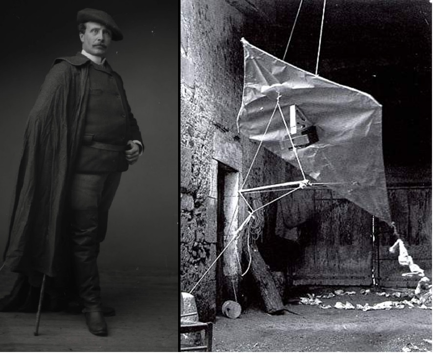
In addition to balloons, kites were being experimented with as possible platforms for aerial photography. Debate exists as to who took the first photograph using a kite. The earliest known attempt occurred in 1849, nine years before Nadar made his 1858 photograph from a balloon. This attempt was made by Colonel Aimé Laussedat of the French Army Corps of Engineers but it was unsuccessful. Later, in 1858, Laussedat tried again using a glass-plate camera that was lifted by several kites. It is not known if he was successful. Some view the first person to take aerial photographs using a kite was the British meteorologist E.D. Archibald. In 1887, he employed a small explosive device to activate a camera shutter exposing a glass plate to the area below the kite. In 1888, Arthur Batut in France built a lightweight camera using a 9x12 cm glass plate for the photographic emulsion. He attached the camera to the wooden frame of a diamond-shaped kite. The camera had an altimeter that encoded the exposure altitude on the film allowing scaling of the image. A slow burning fuse, responding to a rubber band-driven device, actuated the shutter within a few minutes after the kite was launched. A flag dropped once the shutter was released to indicate that it was time to bring down the kite. |
 |
|
Arthur Batut and his Camera-Kite system |
|
In 1890, Batut published a book, entitled La photographie aérienne par cerf-volant. It was the first book on kite photography and it contained an aerial photograph taken in 1889 from a kite over Labruguière, France where he spent most of his life until he died there in 1918. It is believed that in 1887 or 1888 he was the first to use this method successfully. During this same period Batut met Emile Wenz who was also working on kite photography. They developed a close working relationship that lasted many years. Rather than having the camera directly attached to the kite frame they introduced a suspension line on which the camera was located below the kite. The camera could be lowered and reset without bringing down the kite. |
 |
|
First Aerial Photograph from a Kite, Labruguière, France |
|
In the United States, George R. Lawrence was most likely the best known person in the field of kite photography. He was an innovator and his company's slogan was "The Hitherto Impossible in Photography is Our Specialty." He specialized in designing unique camera systems. In the mid-1890s, Lawrence perfected the use of "flashlight photography," which was the norm until flashbulbs were invented years later. In 1900, he built the world's largest camera to take a photograph of the Alton Limited Train, owned by the Chicago & Alton Railway. The below picture illustrates the size of the camera with Lawrence standing beside the lens with a giant lens cap under his left arm and a watch in his right hand making the exposure. The roller curtain operator stands at the rear and all attention is concentrated on the train. The camera weighed 1400 pounds (640 kg) and used a 4.5'× 8' glass-plate negative. The photograph was taken to the 1900 Exposition Universelle (Paris Exposition of 1900) in Paris, France and won "The Grand Prize of the World". |
 |
|
George Lawrence and his Giant Camera |
|
However, his greatest innovations occurred in the areas of aerial photography such as ballooning and camera–carrying kites. He was fascinated with trying to capture panoramic views of the landscape. His initial attempt was to elevate a large camera on a tall ladder. Note the ladder he used to get to the platform and the size of the glass-plate negative in front of his colleague, Dr. Simon Baker. The negative had to be brought up to him and slid into the side of the camera, a difficult task. |
 |
|
Trying To Capture Panoramic Views |
|
Since the large, ground based camera did not provide the panoramic views that he was seeking, he explored ways to get a camera up into the air. He moved toward using a balloon. As with the ground based camera, a balloon with a basket allowed him to have direct contact with the camera and take more than one photograph in a given ascent. With the balloon he could take panoramic pictures of cities and sell the pictures to the residents of the cities. |
 |
|
Reno, Nevada, 1908 |
|
The above photograph shows Reno, Nevada from 1,000 feet over the city. In this example of his work the photograph is looking northeast, centered on the downtown section of the city. He made similar aerial photographs for several different cities as a means of having an income. The Library of Congress has a large collection of these photographs that have been digitized. After a balloon basket in which he was trying to take photos detached from the balloon and sent him plummeting to the ground 200ft below with telephone wires breaking his fall, Lawrence decided to invent a kite system that he called the "Captive Airship." He continued to take aerial photographs of cities but now using kites. |
 |
|
Lawrence's camera and one of his Captive Airships. |
|
Captive Airship used 9 to 17 Conyne kites, strung together by piano wire, to hoist a massive camera into the air. Following the work done by Batut and Wenz, Lawrence did not attach his camera directly to the kites but suspended it below the kites on a separate line that allowed the camera to be lowered and raised without bringing down the kites. The camera was floated between 400 and 2,000 feet in the air before pictures were taken. The lens can be seen in the middle of the flat side of the camera. The film is wrapped around the half drum side of the camera allowing for panoramic pictures to be taken. Before shooting a photograph Lawrence would use binoculars to check the alignment of the lens with the desired landscape. He would then send an electrical impulse generated by an old style telephone magneto to activate the shutter. A device would move the camera in arcs to expose segments of the image to the wrapped around negative. These segments can be seen as the vertical lines in the below image of Kansas City. At times the speed of the device would result in no lines recording on the negative. |
 |
|
Kansas City, 1907 taken from a Captive Airship. |
 |
|
San Francisco 1906 |
|
Lawrence's most famous image is an aerial shot of a burned down San Francisco following the 1906 earthquake and fires. It is a 160-degree panoramic view of the city and was taken from a Captive Airship at 2000 feet in the air above the San Francisco Bay. The entire city appears on a single 17-by-48-inch contact print made from a single piece of film. Each print sold for $125 and Lawrence made at least $15,000 ($432,055 in 2021 dollars) in sales from this one photograph. The camera used to make this photograph weighed 49 pounds and used a celluloid-film plate. The combination of the dark, devastated city landscape and the bright, shinning sunlight made this photograph an artistic symbol, reflecting hope for the city and its inhabitants. |
 |
|
Burned City Blocks on May 19,1906, 41 days after the Great San Francisco Earthquake |
|
On Wednesday, April 18, 1906, at 5:12 in the morning, a massive 7.9 earthquake struck the city of San Francisco. Major aftershocks occurred. Fires started from ruptured gas lines burned an estimated 25,000 buildings covering 490 city blocks. Over 3,000 people perished and more than 80 percent of the city was destroyed. A great number of ground level pictures of this devastating event were taken but none provided an overall view of the degree of destruction as Lawrence's aerial photographs did. Most likely this was the first time that aerial photography was used to show the impact of a natural disaster on a human landscape. |
 |
|
May 1906 and April 1909 Images of Land Use Change in San Francisco |
|
In April 1909, three years after the earthquake and fires, Lawrence returned to San Francisco and took some new aerial photographs. These new photographs make it possible to record change between April 1906 and April 1909. This might be the first time that aerial photography was used to determine land use change. Thus, by photographing the San Francisco earthquake Lawrence not only used aerial photography to record, for the first time, a natural disaster but also, for the first time, to document land use change. It is not clear if he was aware that he was making history with these new applications of aerial photography or if he viewed the recording of these events as a business venture. He had a company to run and may have looked upon the earthquake and fires within an urban environment as a business opportunity for his company. |
|
Pigeon-Based Aerial Photography |
|
Dr. Julius Neubranner was the first person to develop an aerial camera system small enough to be carried by pigeons. He was a chemist (pharmacist) who lived in Kronberg, Germany during the late 1800s-early 1900s. He used pigeons to receive and deliver prescriptions and medications to a nearby sanatorium. He got the idea to use pigeons to take aerial photographs but he needed to create a breast-mounted aerial camera. He developed several models that included a pneumatic timing mechanism to activate the shutter after a set distance, leather harness, and aluminum breastplate. Weighing only 70 grams the camera took exposures at 30-second intervals along the flight line flown by a pigeon. He would release the birds up to 60 miles away knowing that they would take the most direct path back to their dovecote. He worked on his invention between 1903 and 1908 and in 1909 he introduced his birds with their cameras at the Dresden International Photographic Exhibition. |
|
|
|
|
Neubronner applied for a patent that described the original design of the camera. The patent identified two types of camera designs, one with a single lens looking straight down and the other with two lenses orientated ahead and behind the pigeon. In both designs a single exposure is made, time regulated by the deflation of an inflated air-bulb. A cloth shutter with a slit is opened by a spring motor after the delay time expires. Neubronner continued to work on these designs. Later designs had swinging lens to produce panoramic pictures and allowed for more than one exposure. |
|
|
|
|
Neubronner made a business selling both cameras and sets of postcards of the aerial photographs. At fairs and other public events he would send his pigeons up to take pictures. Spectators would watch them arrival back with photos that were immediately developed and turned into buyable postcards. The next several photos provide examples of what the postcards might show. |
|
|
|
|
|
|
|
Although using pigeons to take aerial photographs may appear rather bizarre and novel, various countries have used these birds to conduct spy operations. In 1932, the German army was reportedly training pigeons and had produced a camera capable of 200 exposures per flight. Also in 1932, France announced that it had prepared a camera system for pigeons and was training dogs to release the birds behind enemy lines. In 1942, the Soviet army apparently found German trucks with pigeon cameras that could take photos in five-minute intervals, as well as dogs trained to carry pigeons in baskets. In 1933 a Swiss clockmaker, Christian Michel, was assigned to the Swiss Army's carrier pigeons service to work on adapting Neubronner's panoramic camera to 16 mm film. Michel's camera, patented in 1937, weighed only 70 grams (2.5 oz), and may have been one of the first to have a timer operated by clockwork. During World War II the British Intelligence Branch - MI14(d) - ran a Secret Pigeon Service. Birds were parachuted in a container over Occupied Europe. A questionnaire was attached. More than 1,000 pigeons returned with messages including details of V1 rocket launch sites and German radar stations. |
|
|
|
|
Not to be excluded from the fun, the United States' Central Intelligence Agency (CIA) developed a spy pigeon operation in the 1970s and gave it the codename "Tacana." Although the details of this operation are still classified, the CIA has made some information available. A battery-powered pigeon camera was developed and is now displayed in the CIA Museum's virtual tour. Various news reports indicate that the camera was used in the 1970s and during a testing period pigeons were released from a plane. Test missions showed that the pigeons were very effective and nearly half of the 140 pictures on the roll of film were of good quality. Although no pictures have been made available, CIA remote sensing analysts have stated that people can be clearly identified and the quality of the photography was better than that from the spy satellites operating at the time. The pigeons were to be used against particular targets in the Soviet Union. They were going to be secretly shipped to Moscow. The CIA had several different methods for how to release them. It is not known if Tacana was implemented.The use of pigeons to take aerial photographs is viewed by some as the beginning of the current drone technology. |
|
Rocket-Based Aerial Photography |
|
Alfred Nobel, mainly known for his creation of the Nobel Prizes, had developed among his many inventions a rocket with smokeless solid propellant ballistite. As a very wealthy person Nobel supported many inventors in their work, one being Wilhelm T. Unge. Unge was devoted to the development of rockets and their applications. He and Nobel had several rocket patents and jointly worked on various rocket applications. In mid-1896, Nobel applied for a patent that he entitled "An Improved Mode of Obtaining Photographic Maps and Earth or Ground Measurements." The patent outlined a rocket-based aerial camera system. One photograph would be taken with each rocket launched. A container holding a camera would be deployed from the rocket and float back to Earth using a parachute. While gradually descending a time fuse would release the shutter and a picture would be taken. Nobel died in December 1896 but Unge and his coworkers supposedly continued working on the project and two images were taken of Karlskoga, Sweden on April 26, 1897. Some questions exist pertaining to how the pictures were taken. |
|
|
|
|
|
|
|
In 1903, a German engineer named Alfred Maul developed a rocket system to take photographs from the air. The system was later referred to as the Maul Camera Rocket. A number of people prior to Maul had conducted various tests with rockets, but at the time rocket technology basically lacked any practical application other than maybe military use. |
|
|
|
|
Maul's camera was located in the hood (top) section of the rocket and mounted at an oblique downward inclination. When the rocket started its decent, a time-fuse opened the camera's shutter. The camera lens looked through a hole in the hood. At the same time the first of two parachutes was released to decrease the downward speed of the rocket. The first parachute lowered the rocket to an altitude where a second, larger parachute took the rocket with its camera gradually to the ground. This was done to protect the camera and rocket from damage on encountering the ground. Wings or blades were added to the rocket to keep it from rotating, and thereby, kept the focus of the lens toward the ground. However, the rocket was still inclined to rotate. A gyroscopic device was eventually developed which worked automatically to reduce the rotation. |
|
|
|
|
In 1904 the Maul Camera Rocket took the above image of a North German landscape from about 1,550 feet altitude. From the beginning a military use for this technique was being considered by Maul. In August 1906 secret tests occurred before military observers at a German firing range. After these tests he developed gyroscopic-stabilized plate cameras in 1907 to ensure stable flight and sharper images. Next the rocket camera system was tested by the Austrian Army for reconnaissance in the Turkish-Bulgarian War in 1912/1913. Work on the system was not continued after 1913 due to airplanes being more effective for taking aerial photographs. |
|
George Eastman - Kodak |

George Eastman, founder of Eastman Kodak, was not directly involved with aerial photography but he did play an important role in changing the field of photography, resulting in changes in aerial photography. His initial work in photography occurred mainly during the time period associated with this module. It provided the foundation for the changes that took place in aerial photography during the time period connected with the next module. Due to the early death of his father, Eastman left school at 14 to support his family. At the age of 24 while working in a bank he planned a vacation to Santo Domingo. It was suggested to him to photograph his trip. He acquired a camera but soon discovered that it was very large and required a heavy tripod. Also, a dark room had to be available in order to apply photographic emulsion on glass plates before exposing them, and develop the exposed plates before they dried out. The dark room needed chemicals, glass tanks, a heavy plate holder, and a jug of water. Below is an example of the type of camera one needed to have at the time if one wished to take photographs of a trip. Also below is a picture of a photographic van that provided the dark room and all of the materials and chemicals required to process photographs in the field. Compare this situation to today's smart phones. |
|
|
|
|
Instead of taking the trip he started researching how to make photography less cumbersome and easier for the average person to enjoy. During the day he worked at the bank and at night he experimented at home in his mother's kitchen. He formulated a gelatin-based paper film and a device for coating dry plates. In 1884, he patented the first film in roll form. In 1888, he developed the Kodak camera. It was a very simple box camera with a fixed-focus lens and single shutter speed, which along with its relatively low price appealed to the average consumer. The Kodak came pre-loaded with enough film for 100 exposures and needed to be sent back to the factory for processing the pictures and reloading the camera with a new roll of film. The reloaded camera and pictures were mailed back to the customer. Eastman coined the slogan, "You press the button, we do the rest," By the end of the 19th century Eastman had expanded his lineup to several models including both box and folding cameras. He had basically eliminated the daguerrotype process. |
|
|
|
|
The two below photographs provide a comparison between the daguerrotype process and the Kodak process. The first photograph is a family picture taken around 1910 using a glass plate loaded into a large fixed base camera. It was taken in a photography studio and the family members are all formally dressed for the occasion. The second photograph shows the same family, ten years later, in 1920. Note how informally the family is dressed and that the family is outside and not in a studio environment. This photograph was taken using a hand-held box camera. As we move to the next instructional module we will see how Eastman's rolled film and camera impacted aerial photography during the first half of the 20th century. |
|
|
|
|
Final Comments |
|
1. The period beginning in 1827 with the first photograph and ending in 1914 with the start of World War I saw the development and testing of various aerial photography platforms and cameras by individual inventors, with little or no support from commercial organizations or government agencies. |
|
2. Practically all of the aerial photographs acquired during this period were taken at an angle to the Earth's surface. This type of photography is referred to as oblique aerial photography. Such aerial photography is good for identifying ground features but is difficult for taking ground measurements. |
|
3. Most of the aerial photographs taken during this period were single images and not a series of sequential images along an established flight path. Only Nadar experimented with taking a sequence of aerial photographs. |
|


